Hondius 1663
Nova et exacta tabula geographica Salae et Castellaniae Iprensis, Anno MDCXXXXI = De Casselrie van Ypre = La Chastelenie d'Ipre. [Amsterdam : chez Jean Blaeu, 1663]. |
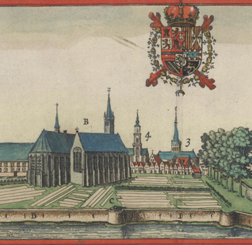
This carte-à-figures originally appeared in Flandria illustrata (1641-1644), a work by Antonius Sanderus, a theologian and historian whose descriptions of Flemish cities and towns are enlivened with numerous plans and views, including detailed depictions of monuments, abbeys, convents, and châteaux. Sanderus travelled throughout Flanders in the early 1630s, commissioning artists and surveyors (including Vedastus du Plouich, whose handiwork is evident in this map) to illustrate his magnum opus. Hondius had originally intended to issue Flandria illustrata, but the Catholic Church took a dim view of a Protestant publishing the work of one of its clergy. In the end, Hondius sold the rights to his competitor, Joan Blaeu, and the book was published in Köln. This map of Ieper (Ypres) and the other illustrations in the book celebrate the rich architectural heritage of Flanders. In the service of glorifying his homeland in Flandria illustrata and other works, Sanderus eventually impoverished himself and, in his old age, sought refuge in the Benedictine Abbey of Afflighem.