Japan 1850
Sekai bankoku Nihon yori kaijō risu kokuin ōjō jinbutsuzu. [Japan : s. n., 1850?] |
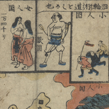
This unusual carte-à-figures, published in Japan during the Tokugawa Era, is a world map centered on Japan (in yellow). The base map used here—heavily stylized—is the planisphere made by the Jesuit Matteo Ricci during his sojourn in China in the late 16th century. Sekai bankoku Nihon reflects Western European cartographic sources not only in its geographical content but also in its inclusion of images of ethnological interest—a feature of Dutch maps that would have been available in Tokugawa Japan . The figures in the margin depict the peoples of various countries—North and South Americans in the right margin ; Indian, Korean, Vietnamese, and Chinese along the bottom edge ; and even more exotic inhabitants of the countries in northern climes (including the Country of Women, the Land of the Monocular People, and the Land of Dwarves).