Reelant 1740
Imperium Japonicum, per regiones digestum sex et sexaginta. Amstelodami : Apud R. & I. Ottens, [1740?] |
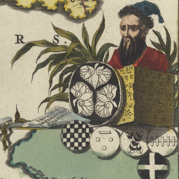
Adriaan Reelant (Reland), professor of oriental languages at the University of Utrecht, created this map of Japan’s 66 provinces from a variety of sources—a Japanese map made by Ishikawa Ryusen (from the collection of Benjamin Dutry, a former director of the East India Company), a Dutch chart of Nagasaki harbor, and imagery from the Atlas Japannensis by Arnoldus Montanus. In Tokugawa Japan (1603-1868), contact with Europeans was strictly limited to trade with the Dutch East India Company—and only through the port of Nagasaki. That commercial arrangement is symbolized by the display of porcelain in front of the cartouche. Despite the Christian motifs, even more prominently featured here, missionaries were personae non gratae under the Tokugawa. The cultural uniqueness of Japan is emphasized by the Sino-Japanese characters identifying the provinces, the noble crests (including the triple hollyhock flowers of the Tokugawa clan), and the images of the samurai, palanquin, and pagoda.