de Fer 1713
Carte de la Mer du Sud et de la Mer du Nord : ou se trouve les costes d'Amerique, d'Asie, d'Europe et d'Afrique situées sur ces mers. Paris : Chez l'Auteur, dans l'Isle du Palais sur le Quay de l'Orloge a la Sphere Royale, avec Privilège du Roy, 1713. |
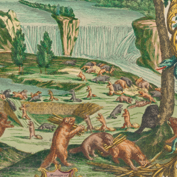
De Fer’s map of the Americas offers an iconographic feast of imagery for those trying to grasp the implications of European colonial intrusion into societies whose “otherness” was their most defining feature. The map seems to suggest both economic opportunities (resources to exploit) and cultural clashes (among peoples whose customs, rites, and mores were so vastly different). The decorative vignettes are adapted from illustrations in various accounts of the first European encounters in the New World. Nicolas Guerard is responsible for the two prominent designs in the North American portion of the sheet: a creative reinterpretation of Hennepin’s description of Niagara Falls and a graphic depiction of the cod fishery. The image of the industrious beavers caught the eye of Herman Moll, who incorporated it into his A New and Exact Map of the Dominions of the King of Great Britain on ye Continent of North America (1715).