Mikel 1671
Plan géométral de la ville de Dijon : levé en 1759 par les ordres de M.M. les Elus Généraux de Bourgogne, et de M.M. les Maire et Echevins de la dite ville / par le Sr. Mikel, Ingenieur Géographe du Roy ; et les vue et ornemens, dessinés par le Sr. Jolivet, Architecte... ; gravé à Paris par Jean Lattré.. Paris : Jean Lattré, rue St. Jacques à la ville de Bordeaux, 1761. |
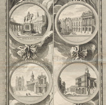
Mikel’s map of Dijon celebrates the architectural splendors of the city. The Palais des États and the Palace Royale—the political heart of the city—take pride of place at the top of the panels flanking the plan of Dijon. Beginning in 1685, these structures took form under the direction of Jules Hardouin-Mansart, chief architect of Versailles in the late 17th century. The statue of Louis XIV, shown here in the Place Royale, was melted down during the French Revolution. The religious institutions featured here include Saint Etienne (now headquarters of the local chamber of commerce), the Couvent des Bernardines (now the Musée d’Art Sacré), and Notre Dame (whose Gothic structure continues to house a church). The views and ornaments were designed by Charles Joseph Le Jolivet, a road surveyor and architect. Several years after this map was published, Le Jolivet became the architect of public buildings. Later, he served as the main contractor responsible for the completion of the Palais des États and its decoration.